 OSU Pytheas - Data Catalog
Meteorological geographical features
Type of resources
Available actions
Topics
INSPIRE themes
Keywords
Contact for the resource
Provided by
Formats
Representation types
Update frequencies
status
Scale
-
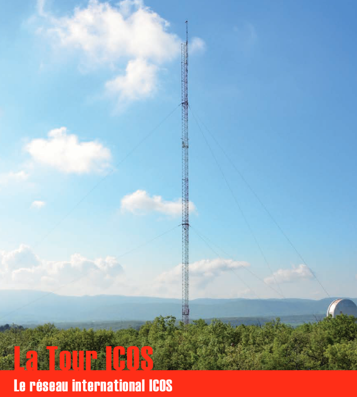
Une infrastructure de recherche européenne de mesure des concentrations atmosphériques des gaz à effet de serre et des flux de carbone sur les écosystèmes et l’océan. La tour ICOS (pour Integrated Carbon Observation System) installée à l'Observatoire de Haute Provence (OHP), haute de 100 m est une antenne régionale du dispositif permettant d’étudier la place de la forêt méditerranéenne dans le bilan de carbone. Elle est équipée d’instruments à trois niveaux (10, 50, 100 m). Le réseau est doté de 3 types de stations réparties sur le territoire : continentales, côtières et de montagne. Chacune de ces stations mesure les paramètres suivants : * température, direction et vitesse du vent, pression atmosphérique, humidité * CO2, CH4, CO, H2O * hauteur de couche limite atmosphérique (lidar) Les objectifs scientifiques de ce programme européen sont de : * tracer les flux de carbone en Europe et dans les régions adjacentes par observation des écosystèmes, de l'atmosphère et des océans à travers des réseaux intégrés, * fournir les observations à long terme nécessaires pour comprendre l'état présent et prévoir le comportement du carbone global et des émissions des gaz à effet de serre, * surveiller et évaluer l'efficacité de la séquestration du carbone et/ou de la réduction des émissions de gaz à effet de serre sur la composition globale de l'atmosphère, en prenant en compte les sources et les puits par région géographique et par secteur d'activité. L'infrastructure ICOS permet d'accueillir des chercheurs pour des campagnes de recherches
-
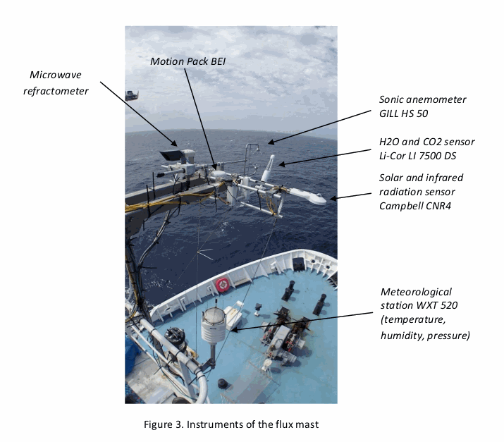
As part of the EUREC4A-OA project (H. Bellenger, S. Speich, LMD), which is the French oceanographic component of the larger EUREC4A field experiments, the “flux mast” national instrument was installed on the Reseach Vessel R/V Atalante from Genavir. The flux mast holds instruments that measure atmospheric turbulence and meteorological variables. The collected data are used to estimate the turbulent fluxes of momentum and heat at the air-sea interface. Specifically, the flux mast instruments measure air pressure, air temperature, humidity, air refraction index, H2O, the three components of the wind vector, and the upward and downward solar and infrared radiation fluxes. The fluxes calculated are the latent and sensible heat fluxes, and the friction velocity. DOI : https://www.seanoe.org/data/00661/77341/
-

Assuming the huge progress achieved in public participatory geographic information system (PPGIS) techniques and its current research gaps, this study aims to explore differences in the perception of spatial distribution of ecosystem services supply and demand between different stakeholders through collaborative mapping. In this case the stakeholders selected included low influence stakeholders (with a high degree of interest on the ecosystem services' state and with a low influence in environmental management). Workshops took place in June 2013 in two regions of Andalusia; overall 29 participants were involved. Three ecosystem services were mapped (erosion control, water depuration and climate regulation).
-

Assuming the huge progress achieved in public participatory geographic information system (PPGIS) techniques and its current research gaps, this study aims to explore differences in the perception of spatial distribution of ecosystem services supply and demand between different stakeholders through collaborative mapping. In this case the stakeholders selected included high influence stakeholder (with a high degree of interest on the ecosystem services' state and with an important influence into the environmental decision making process). Workshops took place in June 2013 in two regions of Andalusia; overall 29 participants were involved. Three ecosystem services were mapped (erosion control, water depuration and climate regulation).
-

Assuming the huge progress achieved in public participatory geographic information system (PPGIS) techniques and its current research gaps, this study aims to explore differences in the perception of spatial distribution of ecosystem services supply and demand between different stakeholders through collaborative mapping. In this case the stakeholders selected included low influence stakeholders (with a high degree of interest on the ecosystem services' state and with a low influence in environmental management). Workshops took place in June 2013 in two regions of Andalusia; overall 29 participants were involved. Three ecosystem services were mapped (erosion control, water depuration and climate regulation).
-
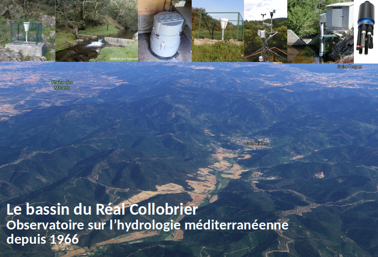
The observatory of the Réal Collobrier basins was set up in 1967 to improve the knowledge of particular hydrological phenomena in the Mediterranean area. Located in forest and rural areas on metamorphic soils of the Massif des Maures in the Var, it is a landmark of regional hydro-climatology. This laboratory is used to develop research on improving the knowledge of Mediterranean hydrology, with a monitoring of rainfall (currently 17 raingauges) and flow (7 water level recorders) on a 70 km² basin, since more than 50 years. Since 2015 the watershed has integrated the SOERE RBV and IR OZCAR. New measuring instruments have been set up (multi-parameter probes, meteorological station, water temperature, automatic sampler, etc.). Scientific objectives around the observatory include the study of flash floods, availability of water resources, study of the interaction between vegetation and the water cycle, knowledge of spatial variability of hydrometeorological processes. These interdisciplinary research axes call for hydrology, soil physics, geomorphology, hydrogeology and biochemistry contribute to the improvement of knowledge, the development of tools and methods in the field of rainfall and climatology, and also to the improvement of the understanding and the modelling of the flows. ---- L'observatoire des bassins de Réal Collobrier a été créé en 1967 pour améliorer la connaissance de phénomènes hydrologiques particuliers en Méditerranée. Situé en forêt et en milieu rural sur les sols métamorphiques du Massif des Maures dans le Var, il est un repère de l'hydro-climatologie régionale. Ce laboratoire permet de développer la recherche sur l'amélioration des connaissances en hydrologie méditerranéenne, avec un suivi des précipitations (actuellement 17 pluviomètres) et des débits (7 enregistreurs de niveau d'eau) sur un bassin de 70 km², depuis plus de 50 ans. Depuis 2015, le bassin versant a intégré le SOERE RBV et l'IR OZCAR.
-
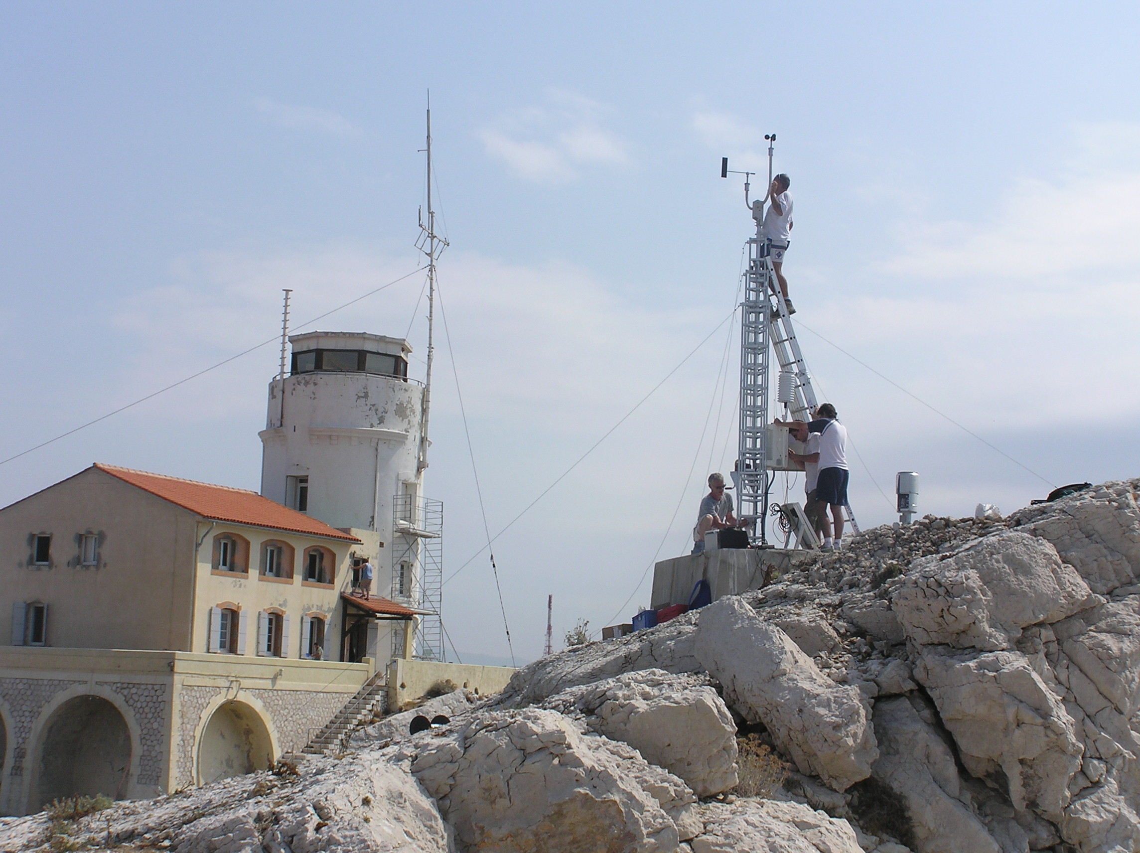
Meteorological data from the Bay of Marseille based on the measurements taken on the site located on the Pomegues island SITE : Iles de Pomègues – Sémaphore du Frioul - Latitude 43°15’59 N - Longitude 5°17’39 W - Hauteur : 25 m PROGRAMME DE RATTACHEMENT : - Mediterranean Oceanic Observing System on Environment : MOOSE - SOMLIT - Labellisation : SOERE - INSU - Financement : SOERE – INSU Read the abstract and supplemental information provided in the Vector template for more details. EQUIPEMENTS: - Station météorologique Auria avec transmission temps réel - Anémomètre et girouette - Baromètre - Pyranomètre - pluviomètre PARAMETRES MESURES : - Vent ( vitesse et direction) - Température et pression atmosphérique - Irradiance - Pluie DISPONIBLITE DES DONNEES : - Visualisation temps réel - Base de données du Service d'Observation du MIO RESPONSABLE : P. Raimbault. PARTICIPANTS : - M. Fornier (Tech Univ) et M. Lafont (Tech Univ) : maintenance - C. Yohia : gestion des données – site web PARTENAIRES : - MOOSE - SOMLIT – MERMEX – CHARMEX -Ville de Marseille - Parc des îles du Frioul -CITATION : Raimbault, P., & Yohia, C. (2017). Météorologie locale en baie de Marseille : Frioul [Data set]. MIO UMR 7294 CNRS. https://doi.org/10.34930/5C9F6377-726B-436B-AA0F-ECC32803EF88
-
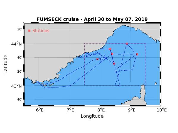
The FUMSECK (Facilities for Updating the Mediterranean Submesoscale - Ecosystem Coupling Knowledge) cruise aimed at performing technological tests of several instruments exploited for the study of the (sub)meso-scale processes and dynamics (from 0.1 to 100 km for a lifetime from several days to several weeks). Three categories of tests have been performed. The first category is the study of the MVP (Moving Vessel Profiler) tracked instruments behaviour, in particular the MSFFFII (Multi Sensor Free Fall Fish, so called "big fish"). We focused on the rotative behaviour of the big fish during its falling and raising, the connectics between the instrument and the MVP cable, between the platform and the boat depth sensor, and between the platform and the PC used to analyse the data, hence testing the whole data acquisition chain. The second category concerns the exploration of several methods to access the measurement of the current velocities vertical component, using different ADCP (Hull-mounted ADCP, Fixed-depth and profiling L-ADCP and Sentinel V (5 beams), Free-Fall ADCP), a prototype of a vertical velocity profiler, and a glider. Finally, we experimented the release of a sample of biodegradable coloured micro-particles at 15m-depth and within a 1 hectare surface, their tracking with drifting buoys, their extraction by pumping and their detection by cytometry. The goal of this experiment was its feasibility, in order to use these micro-particules as tracers for the understanding of the physical part of the ocean biological Carbon pump. Data acquired during the campain are : - Biological oceanography : * B08 Phytoplankton 7 days Continuous sampling for cytometer analysis. 15m-depth sampling for cytometer analysis (3 samples). 30.04.2019 * B90 Other biological/fisheries meas. 1 days GoPro images for the injection, the following and the sampling of coloured micro-particles. 30.04.2019 - Physical oceanography : * D05 Surface drifters/drifting buoys 3 deployments Injection, following, and sampling of coloured micro-particles at 15m-depth. Deployment and recovery of lagrangian drifters anchored at 15m for water mass following. 30.04.2019 * D71 Current profiler (eg ADCP) 7 days Continuous Vessel-Mounted ADCP. L-ADCP and Sentinel casts (5 and 6 stations). Free-Fall ADCP (6 stations). 30.04.2019 * D90 Other physical oceanographic meas. 7 days MVP (Moving Vessel Profiler) 30.04.2019 * D90 Other physical oceanographic meas. 6 stations VVP (Vertical Velocity Profiler) 30.04.2019 * H10 CTD stations 6 stations CTD casts 30.04.2019 * H71 Surface measurements underway (T,S) 7 days Continuous measurement 30.04.2019
-
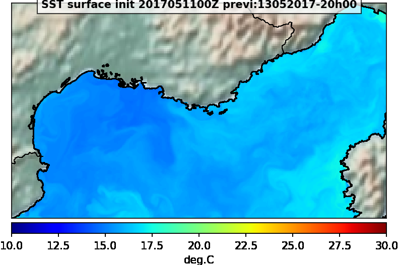
Sortie du modèle MARS3D-ECO3M. Les données disponibles sont la SST, la salinité, la vitesse et direction du courant et la chlorophylle